Khanpur Dam: Epic Scenic Adventure Guide
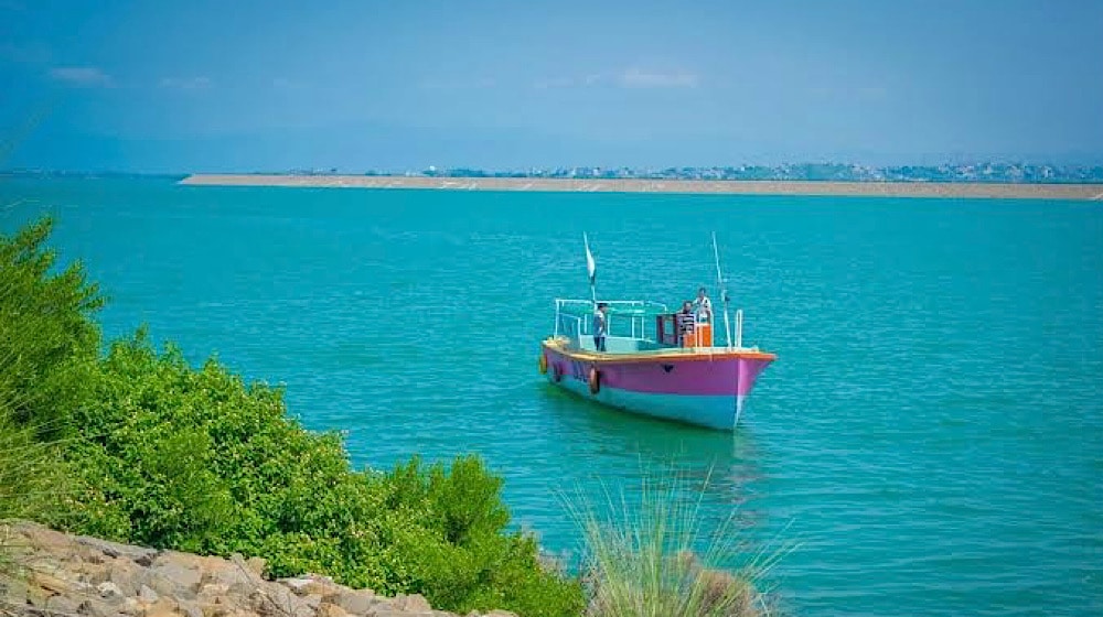
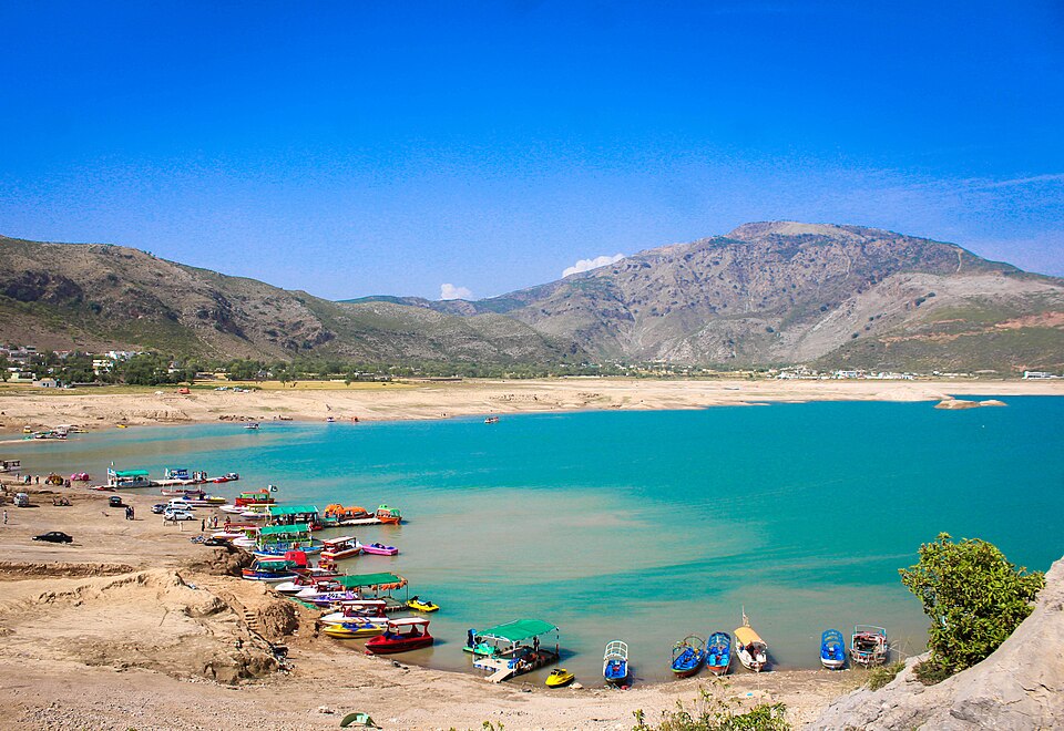
Khanpur Dam is one of the most exciting and scenic outdoor destinations near Islamabad. Known for its turquoise waters, rocky hills, and high-energy adventure scene, the dam has become a favourite spot for families, students, photographers, and thrill seekers alike.
Beyond being a vital water reservoir, Khanpur Dam now offers water sports, paragliding, camping, hiking, and boating, making it a complete outdoor getaway within easy reach of the capital.
This guide covers Khanpur Dam location, distance, weather, resorts, viewpoints, spillway, water sports, and activities, everything you need to plan the perfect visit.
About Khanpur Dam
Khanpur Dam is a major water reservoir built on the Haro River in Khyber Pakhtunkhwa. While its primary function is to supply drinking water to Islamabad and Rawalpindi and support irrigation, its dramatic landscape has transformed it into a tourism hotspot in Islamabad.
Key Facts at a Glance
| Feature | Detail |
| River | Haro River |
| Purpose | Water supply + Irrigation |
| Region | Near Khanpur, Khyber Pakhtunkhwa |
| Popular For | Tourism, water sports, adventure |
Why It’s Famous Today
- Crystal-blue lake surrounded by rugged hills
- Wide range of adventure sports
- Scenic picnic and photography locations
- Easy day trip from Islamabad
The mix of natural beauty and outdoor recreation gives the Khanpur Dam Islamabad region a unique appeal.
Khanpur Dam Location and Distance
The Khanpur Dam location is near the town of Khanpur in Khyber Pakhtunkhwa, situated between Taxila and Haripur. The dam is built on the Haro River and lies within a rocky gorge surrounded by low hills, giving the area a dramatic and scenic landscape.
Although it is outside Islamabad’s city limits, the dam is close enough to serve as a convenient day-trip destination for residents of the capital and Rawalpindi.
Its position between historic Taxila and the green hills of Haripur also makes it a natural stop for travellers exploring northern Pakistan.
Khanpur Dam Distance from Major Cities
The dam’s accessibility is one of the reasons it is so popular. Travel times are manageable even for short weekend outings.
| Route | Distance | Average Travel Time |
| Khanpur Dam distance from Islamabad | 45–50 km | About 1 hour |
| Rawalpindi to Khanpur Dam | 50–55 km | 1–1.5 hours |
| Taxila to Khanpur Dam | 20–25 km | 30–40 minutes |
| Haripur to Khanpur Dam | 35–40 km | 45–60 minutes |
| Lahore to Khanpur Dam distance | 300–320 km | 5–6 hours |
Travel times may increase during peak traffic hours or holiday weekends.
Best Routes to Reach Khanpur Dam
Visitors usually choose one of the following road routes:
From Islamabad / Rawalpindi:
- Islamabad → Taxila → Khanpur Road
- Islamabad → GT Road → Taxila → Khanpur
From the Haripur side:
- Haripur → Khanpur Road
These routes are generally well-maintained, but some stretches near the dam become narrow and winding as you approach the hills.
Transport Options
Following are some of the transport options:
By Private Car
Driving is the most convenient option. It allows flexibility for stops at viewpoints and easy transport of picnic supplies or adventure gear.
By Ride-Hailing Services
Ride-hailing apps operate between Islamabad and Khanpur Dam. This is suitable for small groups but may be costlier for round trips.
By Tour Operators
Adventure clubs and tour companies often run:
- Day trips from Islamabad
- Group packages including water sports
- Camping and paragliding tours
Parking and Arrival Area
Near the lakeside activity zones, visitors will find:
- Open parking areas for cars and vans
- Designated drop-off points for tour groups
- Small stalls and adventure operator counters
On busy weekends, parking areas close to the water fill early, so arriving in the morning is recommended.
Travel Tips Based on Distance
- Start early if travelling from Islamabad to avoid city traffic
- Keep extra travel time during weekends or holidays
- Ensure fuel tanks are sufficient, as fuel stations are limited near the dam
- Use GPS navigation, but follow local signage near the final approach
Khanpur Dam Weather and Best Time to Visit

The experience at Khanpur Dam can vary greatly depending on the weather. Because most activities here are outdoors, including boating, water sports, hiking, and paragliding, choosing the right season and time of day can make a big difference.
Khanpur Dam Weather Overview
Khanpur Dam has a semi-arid climate with hot summers and mild winters. The surrounding rocky hills can intensify daytime heat, while evenings near the water often feel cooler due to lake breezes.
| Season | Temperature Trend | Conditions |
| Spring (Mar–Apr) | Mild to warm | Clear skies, pleasant |
| Summer (May–Aug) | Hot | Sunny, strong sunlight |
| Monsoon (Jul–Sep) | Warm with rain | Occasional showers |
| Autumn (Oct–Nov) | Comfortable | Dry and clear |
| Winter (Dec–Feb) | Cool | Crisp air, sunny days |
Best Time to Visit Khanpur Dam
Spring
Spring is considered one of the best times to visit. The weather is pleasant, the landscape looks fresh, and outdoor activities are comfortable throughout the day.
Best for:
- Water sports
- Hiking and sightseeing
- Photography
Summer
Summer is peak season for water-based fun, though daytime temperatures can be high.
Tips for summer visits:
- Plan water sports in the morning or late afternoon
- Carry sun protection and plenty of water
- Avoid rocky hikes during peak heat
Monsoon
The monsoon season brings occasional rain, making the scenery greener but also increasing the risk of slippery surfaces.
Keep in mind:
- Water activities may be paused during heavy rain
- Trails and rocks can be slippery
- Always check the forecast before visiting
Autumn
Autumn offers comfortable weather and clear skies, making it another excellent time to visit.
Ideal for:
- Paragliding
- Picnics and family outings
- Scenic drives and viewpoints
Winter
Winter days are cool but often sunny, making them suitable for relaxed outdoor trips.
Best for:
- Hiking and nature walks
- Photography
- Quiet picnics
Water sports may be less popular due to cooler water temperatures.
Best Time of Day to Visit
| Time of Day | Experience |
| Morning | Cool air, calm water, fewer crowds |
| Midday | Bright sunlight, peak for water sports |
| Late Afternoon | Pleasant breeze, good for sightseeing |
| Evening | Scenic sunsets, relaxing atmosphere |
Mornings and evenings are the most comfortable, especially in summer.
Weather Tips for Visitors
- Check the forecast before planning paragliding or boating
- Wear breathable clothing in summer
- Bring a light jacket in winter evenings
- Use sunscreen and hats year-round
- Stay hydrated, especially during hot months
Quick Planning Guide
| Goal | Best Season | Best Time |
| Water sports | Spring, Summer | Morning / Late afternoon |
| Paragliding | Spring, Autumn | Late morning |
| Hiking | Autumn, Winter | Morning |
| Photography | Autumn, Winter | Sunrise / Sunset |
| Family picnic | Spring, Autumn | Afternoon |
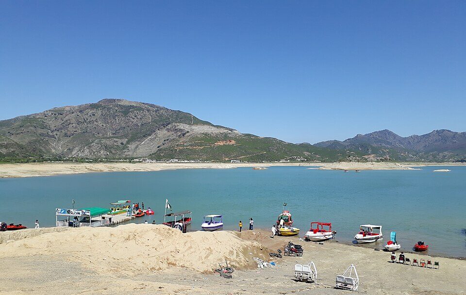
Khanpur Dam Activities and Things to Do
There is no shortage of Khanpur Dam activities for visitors of all ages.
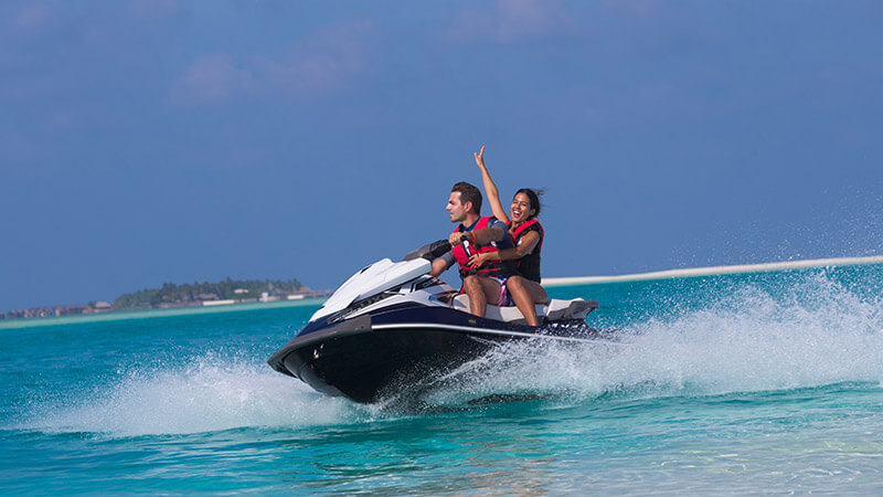
Khanpur Dam Water Sports
The dam is widely known for its water adventure scene.
Popular water sports include:
- Jet skiing
- Speed boating
- Banana boat rides
- Wake tubing
- Cliff diving (with guides)
These activities are operated by local adventure providers near the lakeshore.
Paragliding in Khanpur Dam

Paragliding at Khanpur Dam is a major highlight for thrill-seekers.
Khanpur Dam Paragliding offers:
- Tandem flights with trained pilots
- Panoramic views of the lake and hills
- Unique photo and video opportunities
Flights operate depending on wind and weather conditions.
Land-Based Adventure Activities
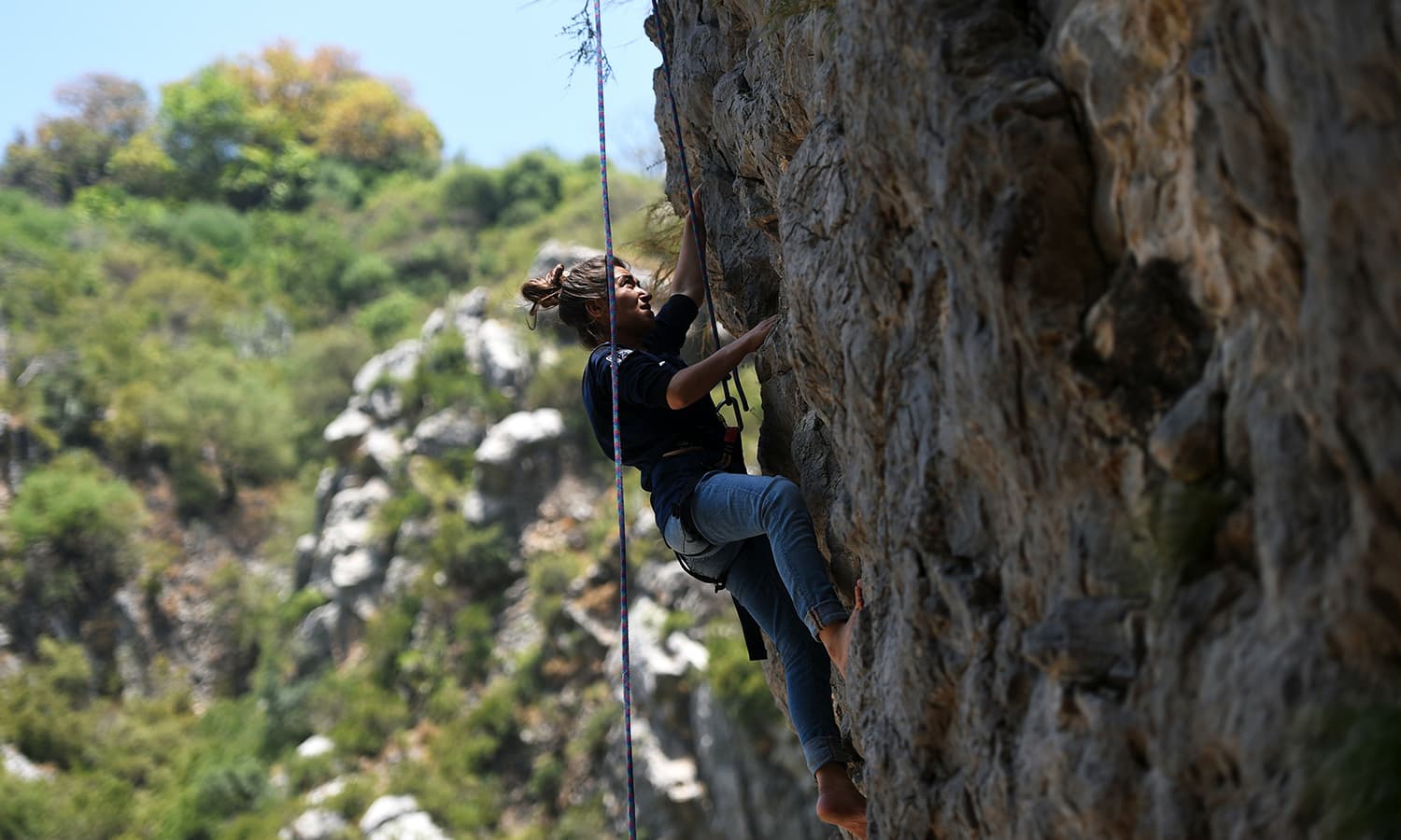
Land adventures include:
- Rock climbing
- Rappelling
- Hiking trails in the surrounding hills
- Camping under the stars
These activities make the area popular for student trips and group outings.
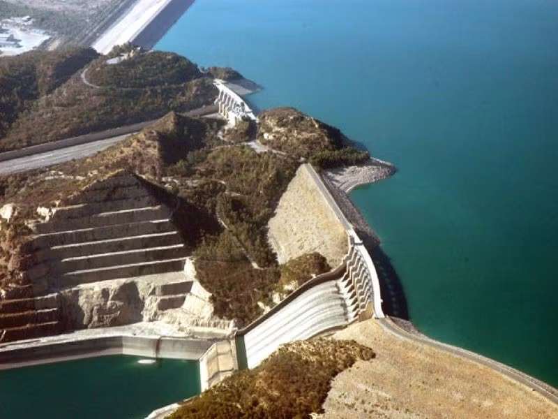
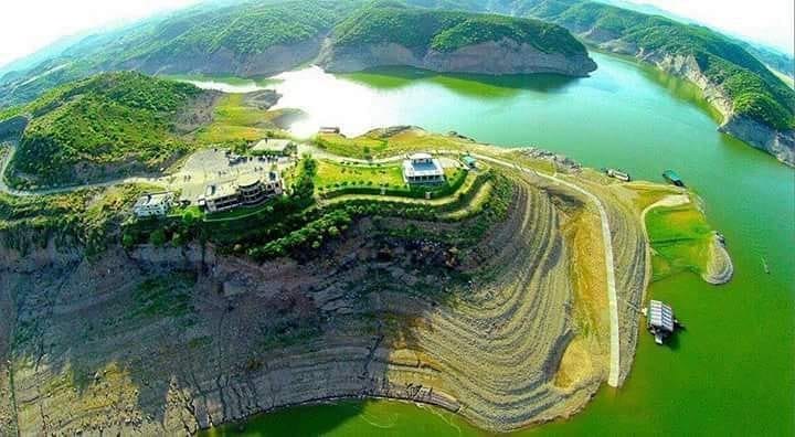
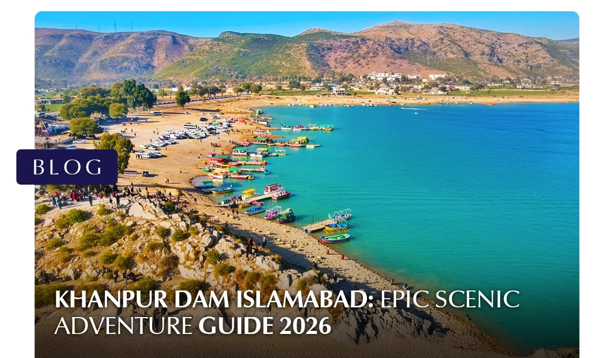
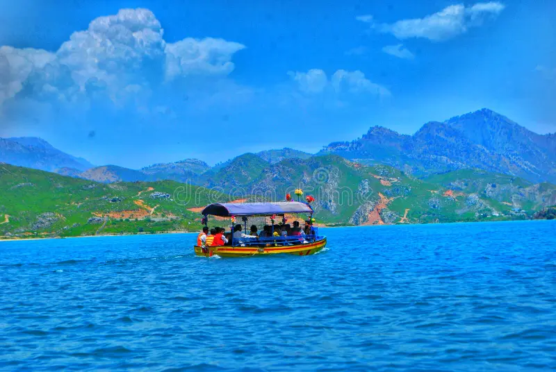
Khanpur Dam Island and Viewpoints
One of the most visually striking aspects of Khanpur Dam is its combination of open water, rugged hills, and elevated vantage points. These natural features create excellent opportunities for sightseeing, photography, and peaceful moments away from the more crowded adventure zones.
Khanpur Dam Island
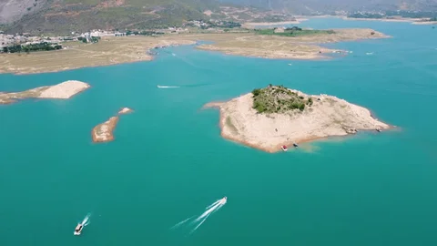
A small landmass commonly referred to as Khanpur Dam Island sits within the reservoir and is one of the lake’s most talked-about features. While not a developed island in the traditional sense, it appears like an isolated patch of land surrounded by deep blue water, making it a scenic highlight.
What Makes the Island Special
- Surrounded by calm lake waters
- Dramatic backdrop of rocky hills
- Popular stop during boat rides
- Ideal for photography from a distance
Boat operators often take visitors near the island area, giving them a close-up view and a chance to capture panoramic photos of the reservoir.
Things to Know Before Visiting
- Direct access to the island itself may not always be permitted
- Conditions depend on water levels and operator policies
- Always follow safety instructions during boat trips
Khanpur Dam Viewpoint Areas
The surrounding terrain offers several natural Khanpur Dam viewpoints where visitors can enjoy elevated views of the reservoir.
Common Viewpoint Locations
- Hilltops along the approach road
- Rocky ledges near adventure activity zones
- Elevated roadside stops overlooking the lake
These spots allow visitors to see the full expanse of the water, the spillway area in the distance, and the surrounding landscape.
Best Times to Visit Viewpoints
| Time | Why It’s Ideal |
| Early Morning | Soft light, calm surroundings |
| Late Afternoon | Cooler weather, clearer skies |
| Sunset | Golden reflections on the lake |
Sunset is particularly popular because the changing light enhances the contrast between the blue water and the brown hills.
Photography Opportunities
The island and viewpoints are especially attractive to photographers.
Popular photo subjects include:
- Wide landscape shots of the reservoir
- Boats moving across the water
- Reflections during sunset
- Aerial-style views from higher ground
A zoom lens can help capture the island more clearly from a distance.
Why These Spots Are Worth Visiting
The Khanpur Dam Island and surrounding viewpoints offer a calmer, more scenic side of the destination. They balance out the high-energy water sports areas by providing space for:
- Quiet reflection
- Scenic walks
- Photography
- Enjoying nature’s scale and beauty
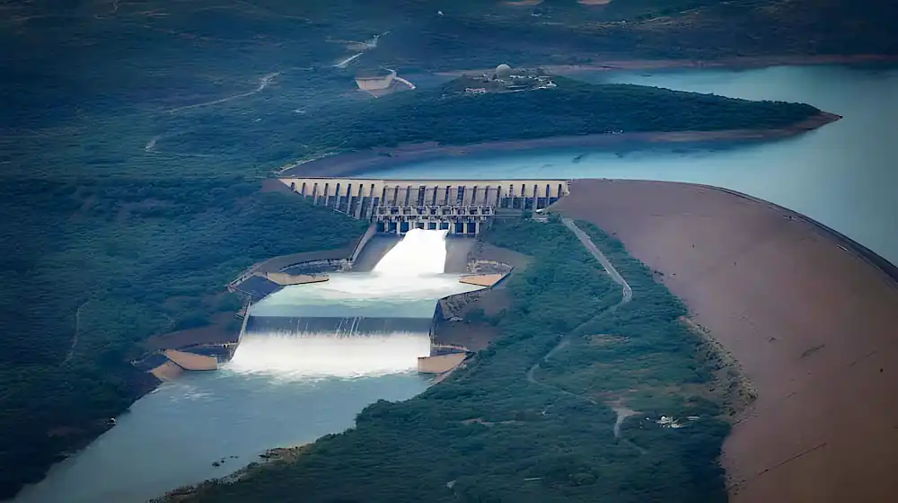
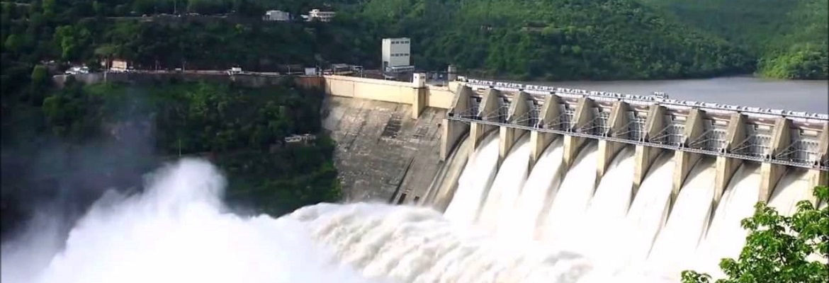
Khanpur Dam Spillway
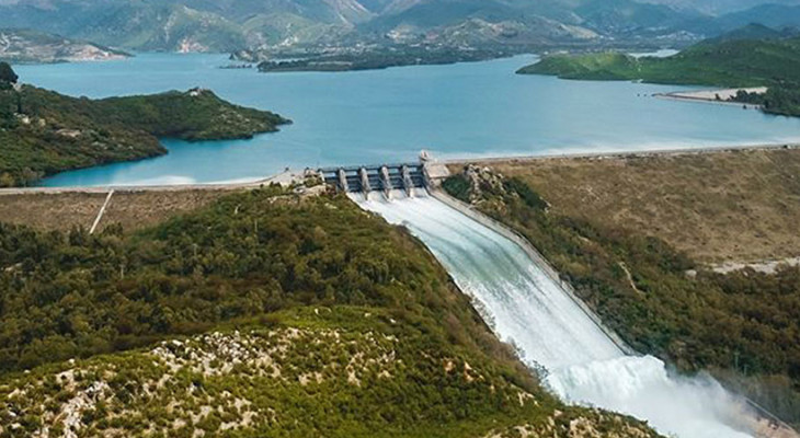
The Khanpur Dam spillway is one of the most important structural features of the dam. While many visitors come for recreation and adventure, the spillway highlights the dam’s engineering and plays a vital role in water management and safety.
What is the Spillway?
A spillway is a controlled channel that allows excess water to flow out of a reservoir when water levels rise beyond safe limits. At Khanpur Dam, the spillway helps regulate the reservoir’s capacity and prevents overflow that could damage the structure or surrounding areas.
Viewing the Khanpur Dam Spillway
Direct access to the spillway is often restricted for safety reasons, but visitors may view it from:
- Elevated viewpoints around the reservoir
- Designated observation areas
- Roadside vantage points at a safe distance
Always follow local guidelines and avoid entering restricted zones.
Photography Opportunities
The spillway becomes especially impressive when water is flowing at full force.
Ideal conditions for photos:
- After heavy rainfall
- Clear daylight for sharp contrast
- From elevated viewpoints for a wide-angle shot
Long-exposure photography can capture the smooth motion of cascading water.
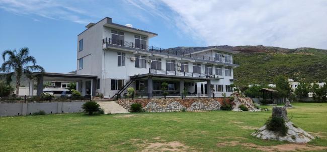
Khanpur Dam Resort and Hotels
While many visitors explore Khanpur Dam as a day trip, staying overnight allows more time to enjoy the scenery, adventure activities, and peaceful atmosphere around the reservoir. Accommodation options range from basic guest houses to private resorts and organised camping experiences.
Khanpur Dam Resort Options
A few private facilities and lakeside setups operate near the dam, offering a resort-style experience for visitors who want comfort alongside adventure.
What Resorts Typically Offer
- Rooms or huts with views of the lake or surrounding hills
- On-site dining or BBQ arrangements
- Activity packages including water sports or paragliding
- Outdoor seating areas for relaxation
These resorts are often chosen by families, couples, and corporate groups looking for a short getaway close to nature.
| Area | Type of Accommodation | Distance to Dam |
| Khanpur Town | Guest houses, small hotels | 10–15 minutes |
| Taxila | Budget and mid-range hotels | 30–40 minutes |
| Haripur | Hotels and lodges | 45–60 minutes |
| Islamabad | Wide range of hotels | About 1 hour |
Staying in Islamabad provides the most comfort and dining options, while staying closer to Khanpur allows earlier access to activities.
Camping Near Khanpur Dam
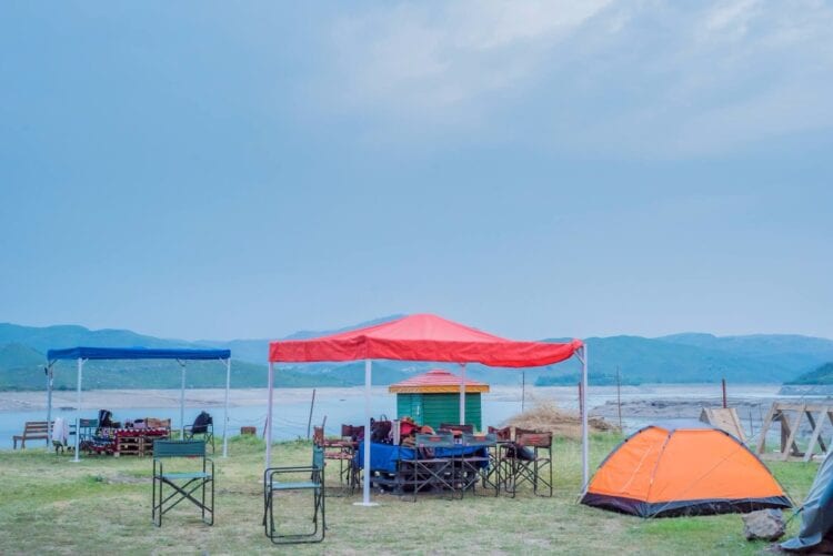
Camping is a popular alternative for adventure enthusiasts.
Camping Options Include
- Organised camping trips by adventure clubs
- Tented stays near designated safe areas
- Group camping packages with meals and activities
Camping allows visitors to enjoy the night sky, early morning lake views, and a quieter environment after day tourists leave.
Travel Tips for Visiting Khanpur Dam
Safety Tips
- Always wear life jackets during water sports
- Choose certified operators
- Avoid slippery rocks during the monsoon
Comfort Tips
- Carry sunscreen and hats
- Wear sturdy shoes
- Bring extra water
Timing Tips
- Arrive early on weekends
- Avoid midday heat in summer
- Check the weather before booking paragliding
Frequently Asked Questions
How far is Khanpur Dam from Islamabad?
The Khanpur Dam distance from Islamabad is about 45–50 km.
What activities are available at Khanpur Dam?
Visitors can enjoy water sports, paragliding, hiking, camping, boating, and photography.
Is paragliding available at Khanpur Dam?
Yes, Khanpur Dam Paragliding is a popular activity when weather conditions are suitable.
What is the best season to visit Khanpur Dam?
Spring and autumn provide the most comfortable weather.
Final Thoughts
Khanpur Dam offers a rare blend of natural beauty and high-energy adventure close to Islamabad. With its exciting water sports, scenic viewpoints, paragliding experiences, and relaxing picnic spots, it remains one of the top outdoor destinations in the region. Whether you’re looking for adrenaline or a peaceful lakeside escape, Khanpur Dam delivers both in one unforgettable setting.
For more informative blogs on topics like Daman-e-Koh, visit Chakor Blogs.