When rivers burst their banks and valleys roar with water, the devastation is immediate, and today, Pakistan is living this reality once again. In 2025, flash floods have battered Gilgit-Baltistan and Khyber Pakhtunkhwa, while Punjab struggles with rising river levels and prolonged inundation. These floods are not isolated events; they are part of a growing pattern shaped by climate extremes, fragile infrastructure, and vulnerable communities.
Floods come in many forms, but two stand out for their frequency and impact flash floods and riverine floods. Both are destructive, yet they differ in how they form, how quickly they strike, and the scale of their impact.
Understanding these differences is more than academic; it is critical for saving lives, protecting livelihoods, and planning for Pakistan’s uncertain climate future.
This article explores flash floods and riverine floods in depth, highlighting cause and effect of flash flood and riverine flood, global and local examples, and the lessons unfolding in 2025 as Pakistan battles yet another season of water-driven disasters.
Types of Flood
Floods are universal disasters, striking from the river valleys of Europe to the coastal plains of Asia and the deserts of the Americas. They occur when water overwhelms natural or man-made boundaries, disrupting communities, economies, and ecosystems. Yet, not all floods behave the same way.
Some develop in mere minutes, while others build over weeks; some are localized in steep valleys, while others engulf entire river basins.
Globally, scientists categorize floods into distinct types, each with its own triggers and impacts.
For countries like Pakistan where mountains, glaciers, rivers, and densely populated plains all coexist these global categories are not theoretical. They are realities that repeat year after year.
Flash Flood
A flash flood in Pakistan is one of the fastest-developing and most dangerous forms of flooding. Triggered by intense rainfall, sudden snowmelt, or the failure of natural dams, flash floods can rise within minutes and sweep away everything in their path.

Globally, flash floods have devastated regions from the arid canyons of the American Southwest to the mountain valleys of the Himalayas. Their hallmark is speed and force, water laden with debris surges through narrow channels with little to no flash flood warning.
Similar conditions exist in Gilgit-Baltistan and Khyber Pakhtunkhwa, where steep valleys and glacial landscapes create a high risk of such flash floods in Pakistan.
Riverine Flood
Riverine floods, also known as fluvial floods, develop more slowly but on a much larger scale. They occur when rivers and their tributaries overflow after prolonged rainfall, snowmelt, or upstream dam releases.
Globally, major river basins like the Mississippi, Yangtze, and Danube have witnessed destructive riverine floods that lasted weeks and submerged vast tracts of land.
In South Asia, the Indus and Ganges river systems are no different. While the definition is universal, the lived experience in Pakistan is clear: seasonal monsoon rains routinely swell the Indus and its tributaries, turning fertile plains into temporary inland seas.
Other Types of Floods
- Urban Floods – A growing global issue in mega-cities from Houston to Mumbai, where intense rain overwhelms drainage systems. Pakistani cities like Lahore and Karachi face the same challenge each monsoon.
- Coastal/Storm Surge Floods – Seen globally during hurricanes in the U.S. and typhoons in East Asia, storm surges push seawater inland. Pakistan’s Sindh and Makran coasts are similarly at risk during cyclones in the Arabian Sea.
- Glacial Lake Outburst Floods (GLOFs) – Common in high-mountain regions like the Andes, Himalayas, and Alps, where melting glaciers form unstable lakes. Northern Pakistan, home to thousands of glaciers, faces comparable threats.
- Dam/Embankment Failure Floods – From historic failures like the Banqiao Dam in China (1975) to smaller breaches elsewhere, these floods occur when human-built barriers collapse. In Pakistan, embankment breaches along the Indus often exacerbate monsoon flooding.
Flash Floods in Depth
Flash floods are among the most sudden and destructive water hazards, capable of upending lives and landscapes in minutes. From global mountains to Pakistan’s northern valleys, they follow similar triggers but manifest locally in uniquely devastating ways.
Physical Triggers & Meteorology
- Short‑Duration, High‑Intensity Rainfall (SDHI): Flash floods develop within six hours of intense precipitation, sometimes in under three creating rapid water surges in small streams or urban flood zones. The Guardian GPM by NASA
- Orographic Uplift: Mountain ranges force moist air upward, intensifying localized downpours, common in regions like the Himalayas and Pakistan’s GB and KP.
- Glacial Lake Outburst (GLOF) & Debris Flows: Sudden breaches in glacial lakes or melting instabilities can release massive torrents, especially where moraine dams are weakening.
- Channel Constrictions & Snowmelt Surges: Narrow valleys funnel floodwaters rapidly downstream, while snowpack melts can amplify flows during warm spells.
Human & Land-Use Drivers
- Deforestation reduces soil stability and slows infiltration, amplifying surface runoff.
- Road Cuts & River Encroachments alter flow paths, accelerating inundation in vulnerable zones.
- Poor Culvert Design blocks water flow under infrastructure, amplifying flood heights.
- Unplanned Hill Settlements mean communities often build in high-risk channels, limiting safe evacuation.
Hydrology & Warning Lead Time
- Rapid Onset gives only minutes to a few hours for warnings and response—the hallmark of flash floods.
- Runoff Coefficients & Flashy Hydrographs: Steep topography yields fast‑rising hydrographs; even small rain events can result in swift and violent water movement.
- Limitations of Warnings: Sparse sensors and limited lead time severely constrain actionable alerts, especially in remote mountainous terrain.
Global Case Snapshots
| Region | Trigger | Highlight |
| Uttarakhand, India | Cloudburst & SDHI rainfall | 2013 disaster underlines Himalayan vulnerability |
| Western Europe (Eifel) | Extreme summer storm (2021) | Flash flooding in canyon landscapes |
| U.S. Southwest | Rainstorms in narrow slot canyons | Sudden deluges in popular hiking areas |
Flash Flood History in Pakistan
Historically, Pakistan’s northern regions have faced repeated flash flood disasters driven by sudden, intense cloudbursts. In Khyber Pakhtunkhwa and Gilgit-Baltistan, these abrupt storms have often overwhelmed narrow valleys, washing away homes, roads, and farmland within hours.
Beyond rainfall, the threat of Glacial Lake Outburst Floods (GLOFs) has long haunted high-altitude basins. In areas like Hunza, glacier-dammed lakes have breached, especially before 2010, sending torrents of water and debris surging downstream.
These events not only destroy local infrastructure but also highlight how fragile mountain ecosystems remain under the pressures of climate change and human settlement.
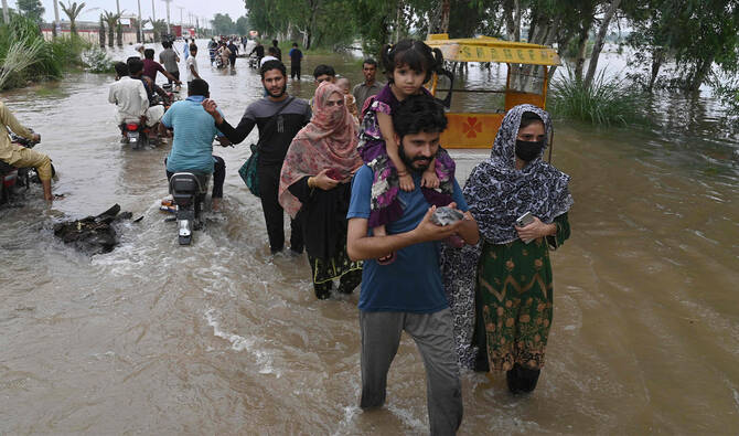
Floods in Pakistan – 2025 Pakistan Focus
Gilgit-Baltistan
- Events: GLOF‑like bursts and SDHI downpours have washed out roads and bridges, isolating valleys. For example, near Gilgit town, a newly formed 7 km lake emerged following a mountain mudslide.
- Impacts:
- Lives lost, especially in isolated communities.
- Physical isolation due to damaged infrastructure.
- Loss of tourism income and damage to hydropower intakes.
Khyber Pakhtunkhwa
- Events: Torrential rain triggered deadly hill torrents across districts like Swat and Buner.
- Human Toll: Over 400 people have died in KP alone this season, with Buner recording more than 200 fatalities.
- Impacts:
- Homes submerged or swept away.
- Agricultural land and livestock devastated.
- Displacement into temporary shelters.
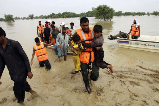
Responses & Gaps
- Existing Actions:
- Emergency alerting via SMS and community sirens in some areas.
- Slope stabilization and minor infrastructure checks underway.
- Gaps:
- No comprehensive real-time GLOF monitoring system.
- Inadequate early-warning dissemination in remote valleys.
- Weak land-use regulation and setback enforcement near watercourses.
Riverine (Fluvial) Floods in Depth
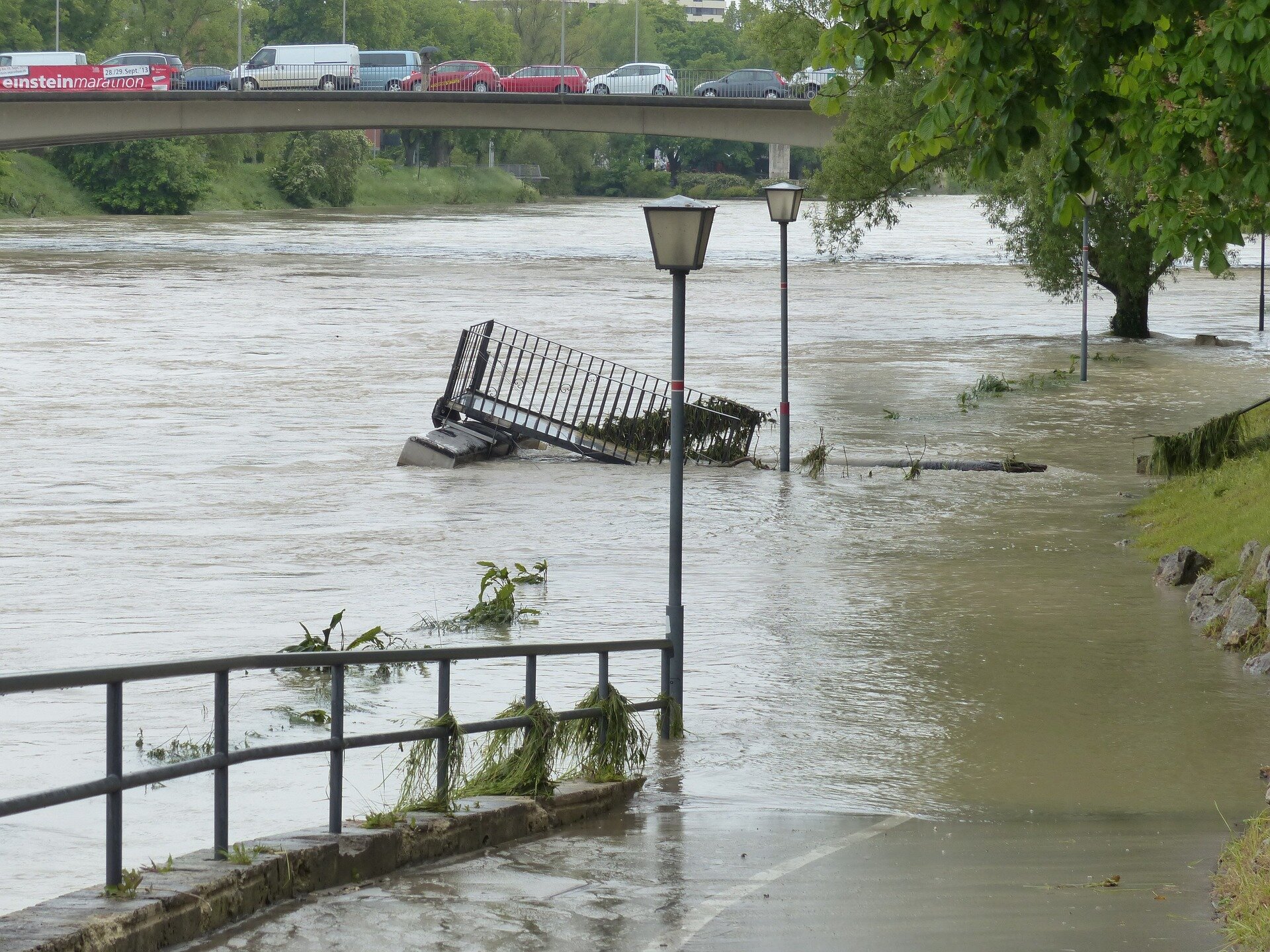
Riverine floods, also known as fluvial floods, occur when rivers overflow their natural or artificial banks, inundating surrounding floodplains. Unlike flash floods, they usually build up over days or even weeks, covering vast areas with slow-moving water.
Globally, these floods are the most common and costly type of flooding, often linked to persistent rainfall, snowmelt, and upstream water management decisions.
For a country like Pakistan, where the Indus Basin dominates agriculture, settlements, and infrastructure, riverine floods remain the single greatest water hazard.
Physical Triggers & Basin Dynamics
Several natural and hydrological factors combine to create riverine floods:
- Persistent Monsoon Systems – Extended rainfall across catchments saturates the soil and drives rivers beyond capacity.
- Upstream Dam Releases – Reservoirs on both domestic and transboundary rivers may release water during peak flows, amplifying downstream flooding.
- Snow and Glacier Contributions – Melting glaciers in summer contribute to higher base flows in northern rivers.
- Flood Routing & Travel Times – Riverine floods travel downstream as waves, with flood crests sometimes taking days to reach lower floodplains.
- Backwater Effects – When one river’s high stage slows the flow of another (e.g., Chenab and Ravi confluences), water backs up and prolongs inundation.
Human & Infrastructure Drivers
Human activity often magnifies natural flood risks:
- Embankment Breaches – Weak or poorly maintained levees collapse, letting water rush into settlements.
- Siltation of Channels – Reduced channel capacity due to sediment buildup increases flood frequency.
- Encroachment on Floodplains – Expansion of housing and farming into natural flood zones leaves communities highly exposed.
- Drainage Congestion – Poor urban and rural drainage systems trap floodwater for weeks.
- Barrages and Operating Rules – Mismanagement of barrages and canals sometimes intensifies inundation downstream.
Global Case Snapshots
| Region/Year | Flood Trigger | Impact |
| Mississippi Basin, USA | Heavy seasonal rains + snowmelt | Repeated floods (1927, 1993) displaced millions and caused billions in losses. |
| Yangtze River, China | Prolonged summer monsoons | 1998 floods affected over 200 million people. |
| Central Europe (Danube & Elbe) | Stationary rain systems (2002, 2013) | Urban inundation and agricultural losses across Germany, Austria, Hungary. |
Pakistan Case Snapshots (Historic)
Riverine floods have repeatedly reshaped Pakistan’s economy and landscape. Some of the most severe events include:
- 1973 – Indus floods damaged millions of hectares of crops; highlighted weak embankment design.
- 1988 – Widespread monsoon flooding; showed gaps in forecasting and early warning.
- 1992 – Chenab and Jhelum floods devastated Punjab districts; emphasized basin-wide coordination needs.
- 2010 – Among Pakistan’s worst disasters: 20 million affected, $10 billion in losses, massive displacement across provinces.
- 2014 – Floods in Punjab exposed vulnerabilities of urban centers like Jhang and Multan.
2025 Pakistan Focus — Ongoing Punjab Floods
The monsoon of 2025 has once again triggered widespread riverine flooding across Punjab. According to NDMA and FFD bulletins:
- Rivers Involved: Indus, Jhelum, Chenab, Ravi, and Sutlej are all in high or very high flood stages, influenced by heavy monsoon rainfall and dam releases from upstream India.
- Impacts:
- Thousands of hectares of agricultural plains under water, threatening rice and cotton harvests.
- Canal systems and rural settlements submerged, forcing mass displacement.
- Livestock losses reported in several districts.
- Supply chain disruption affecting local markets and logistics corridors.
- Many of the housing societies have been swept away including Park View City Lahore which was significantly impacted after the water breaching protective wall alongside the Ravi river.
- Operational Issues:
- Stress on key embankments near Jhang, Multan, and Muzaffargarh.
- Controlled breaches carried out in some areas to save major cities.
- Relief camps set up but struggling with overcrowding, WASH (water, sanitation, hygiene), and food shortages.
- Mitigation Actions (as highlighted by NDMA & UNDRR best practices):
- Forecast-based financing to release emergency funds before disaster peaks.
- Pre-positioning relief supplies in vulnerable districts.
- Levee and embankment inspections with reinforcement where possible.
- Long-term solutions: polders, retention basins, and floodplain zoning to reduce future exposure.
Flash Flood vs Riverine Flood — Key Differences
| Factor | Flash Flood | Riverine Flood |
| Onset & Duration | Develops within minutes to a few hours after intense rainfall or GLOF. (NASA GPM, Weather.gov) | Builds over days to weeks with prolonged rainfall, snowmelt, or upstream dam releases. (FEMA, FloodSmart.gov) |
| Geography | Common in steep valleys, small mountain catchments, and urban gullies where runoff is rapid. | Found across large river basins and broad floodplains, often covering thousands of km². |
| Warning Lead Time | Very short, often only minutes to a few hours making evacuations difficult. | Longer lead times (hours–days) possible due to monitoring of river stages. |
| Main Triggers | Cloudbursts, GLOFs, snowmelt surges, dam failures. | Prolonged monsoon rains, upstream dam releases, saturated catchments, glacier contributions. |
| Water Behavior | High-velocity torrents, often debris-laden and destructive. | Broad inundation with slower rise; water may remain for weeks. |
| Primary Damages | Roads, bridges, hill settlements, tourism routes (e.g., Karakoram Highway). | Crops, housing, livestock, markets, and wide-area infrastructure (canals, barrages, power). |
| Best Mitigation | Hyperlocal early warning, slope stabilization, culvert/channel redesign, safe setbacks. | Floodplain zoning, embankments, reservoirs, polders, and “Room for River” strategies. |
| 2025 Pakistan Focus | Gilgit-Baltistan & Khyber Pakhtunkhwa: flash events, GLOFs, road/bridge washouts, loss of life (Guardian, ReliefWeb). | Punjab: widespread Indus/Jhelum/Chenab/Ravi/Sutlej flooding, agricultural devastation, displacement (NDMA, FFD bulletins). |
Causes and Effects of Floods
Floods are rarely the result of a single factor. They emerge from the interplay of climate change, natural hydrological cycles, and human decisions around land use, infrastructure, and governance.
Understanding their causes alongside their effects offers a fuller picture of why these disasters are so devastating, and why Pakistan in 2025 remains acutely vulnerable.
Climate Signals
- A Warmer Atmosphere: Rising global temperatures allow the atmosphere to hold more moisture, producing short-duration, high-intensity rainfall events. This explains why cloudbursts and extreme monsoon spells are becoming more frequent in South Asia.
- Glacier Retreat & GLOF Risks: Pakistan’s northern mountains contain over 7,000 glaciers. As they retreat, unstable moraine dams form lakes that can breach suddenly, causing Glacial Lake Outburst Floods (GLOFs). UNDRR lists these as among Pakistan’s fastest-growing risks.
- Monsoon Variability: Climate change distorts the South Asian monsoon, making it erratic, prolonged, or stalled over one region. Such “stuck” systems contributed to Europe’s 2021 floods and are playing a role in Pakistan’s prolonged 2025 inundations in Punjab.
Non-Climate & Governance Factors
- Land-Use Change & Deforestation – Removal of natural vegetation accelerates runoff and erosion, especially in KP and GB.
- Encroachment on Floodplains – Settlements and farming expand into riverbeds, leaving millions directly in harm’s way.
- Poor Drainage & Maintenance Deficits – Outdated urban systems in Lahore, Karachi, and Multan fail during monsoons, causing prolonged waterlogging.
- Weak Zoning & Regulation – Lack of enforcement allows construction in hazard-prone zones, amplifying damages.
- Data Gaps & Sparse Gauging Networks – Limited rainfall and river monitoring reduce the accuracy of forecasts, leaving early-warning systems underpowered.
- Fragmented Planning – Barrage operations, embankment management, and dam releases are often reactive, not coordinated, compounding risks.
Effects of Floods
Floods leave a multidimensional imprint, extending far beyond the immediate disaster.
Human & Social Impacts:
- High Mortality & Injuries – 2025 flash floods in Punjab and KP already claimed hundreds of lives.
- Mass Displacement – Thousands of families forced into temporary shelters in Punjab, facing overcrowding and WASH challenges.
- Schooling Interruptions – Many schools are closed or converted into relief camps.
- Psychosocial Stress – Trauma from sudden displacement and loss of loved ones, especially among children and women.
Economic & Infrastructure Impacts
- Agriculture – Crop losses are immense, with rice and cotton in Punjab submerged during peak growing season.
- Supply Chains – Flooded highways and washed-out bridges disrupt logistics across provinces.
- SMEs & Livelihoods – Small businesses suffer from destroyed inventory and reduced footfall.
- Power & Telecom – Hydropower stations in GB and KP damaged, while submerged telecom lines cut communication.
Environmental Impacts
- River Morphology Changes – High flows reshape channels, eroding banks and creating new flood paths.
- Sediment Pulses – Increased siltation reduces river capacity, worsening future floods.
- Groundwater – Some recharge occurs, but contamination from sewage and chemicals raises health risks.
- Ecosystem Shifts – Wetlands temporarily expand, while farmland fertility declines due to waterlogging and salinization.
Preparedness & Mitigation
Flood disasters cannot be eliminated, but their impacts can be significantly reduced through smart planning, timely action, and resilient recovery. Strategies vary depending on the type of flood and the region, but common threads include stronger early warning systems, better land management, and community-driven preparedness.
For Flash Flood-Prone Regions (GB, KP)
The steep valleys and glacial landscapes of Gilgit-Baltistan and Khyber Pakhtunkhwa demand localized, rapid-response strategies:
- Hyperlocal Sirens & Cell Broadcasts – Quick alerts through SMS and village sirens save lives when minutes matter. UNDRR notes that even low-cost systems can dramatically reduce casualties.
- Community Spotters & Volunteers – Trained locals equipped with radios act as the first line of warning in remote valleys.
- Culvert Redesign & Catch Drain Maintenance – Infrastructure must be adapted to withstand debris-laden surges, preventing bottlenecks.
- No-Build Buffers – Restricting settlements in riverbeds and steep gullies reduces exposure.
- Micro-Retention & Check Dams – Small retention structures upstream slow runoff and reduce flood peaks.
- Slope Bio-Engineering – Tree planting and vegetative barriers stabilize soil and reduce landslide-triggered floods.
For Riverine Punjab
Punjab’s vast floodplains require systemic and long-term measures rooted in basin-scale planning:
- Forecast-Based Financing – NDMA and partners increasingly advocate for releasing funds once rainfall/river thresholds are reached, ensuring relief arrives before peak floods.
- Floodplain Zoning & Buy-Backs – Limiting new settlements in high-risk zones and relocating existing ones away from riverbanks.
- Embankment Audits – Regular inspections and reinforcement of levees and barrages to prevent catastrophic breaches.
- Controlled Spillways & Polders – Purpose-built spill zones and storage basins reduce pressure on rivers.
- “Room for the River” Approach – Allowing rivers to reclaim part of their natural floodplain lowers long-term risk, as seen in European models.
- Climate-Resilient Agriculture – Adoption of flood-tolerant seed varieties, crop calendar shifts, and raised-bed farming to protect farmers’ livelihoods.
Response & Recovery
Even with preparedness, floods will occur. Effective response and recovery ensures communities bounce back stronger:
- Evacuation Routes & Signage – Clearly marked, accessible evacuation paths integrated into village and city planning.
- Inclusive Shelters – Relief camps with adequate WASH (water, sanitation, hygiene) facilities, space for women and children, and designated pens for livestock.
- Damage Assessments – Use of drones, satellites, and GIS mapping to quickly evaluate damages and prioritize aid distribution.
- Cash Transfers & Relief Packages – Direct financial support to affected families provides dignity and flexibility in recovery.
- Rebuild-Better Standards – Reconstruction of homes, schools, and health centers using flood-resistant materials and elevated designs to withstand future events.
FAQs
How many types of flood are there?
There are several types including flash floods, riverine (fluvial) floods, urban floods, coastal floods, GLOFs, and dam/embankment failures.
What is the difference between a flash flood and a riverine flood?
Flash floods occur within minutes to hours after intense rain or GLOFs, while riverine floods develop slowly over days or weeks across large basins.
Why are flash floods common in Gilgit Baltistan and KP?
Steep valleys, heavy cloudbursts, melting glaciers, and unstable mountain terrain make these regions highly prone to flash floods.
What causes riverine floods in Punjab?
Prolonged monsoon rains, saturated catchments, and upstream dam releases swell rivers like Chenab, Ravi, and Sutlej, causing widespread inundation.
What is the current flood situation in Punjab, especially near the Chenab River?
Punjab faces ongoing floods in 2025, with the Chenab and its tributaries inundating farmland, villages, and displacing thousands.
What is a flash flood?
A flash flood is a sudden, high-velocity flood that develops within minutes to a few hours after intense rainfall or rapid water release.
What is a riverine flood?
A riverine flood is the gradual overflow of rivers and streams onto surrounding floodplains, usually lasting days to weeks after prolonged rains or snowmelt.
What is the flood situation near Chenab River?
The latest updates on water levels and flood forecasts for the Chenab River are available on the Pakistan Meteorological Department – Flood Forecasting Division.
This was all about Differences between flash floods and riverine floods. For more details, visit Chakor blogs.